Zambezi River : The Tonga people gave the Zambezi River its name, which means “Big River.” The Zambezi ranks fourth in length in Africa, after the Nile, the Congo, and the Niger. It’s Africa’s longest river that flows eastward.
From its beginnings in northern Zambia to the Indian Ocean is an incredible 2,700 kilometers of river flow across six different countries.
Given that so few of the world’s rivers are as unspoiled and uncharted as this one, it’s easy to see why it conjures such feelings of mystery and adventure.
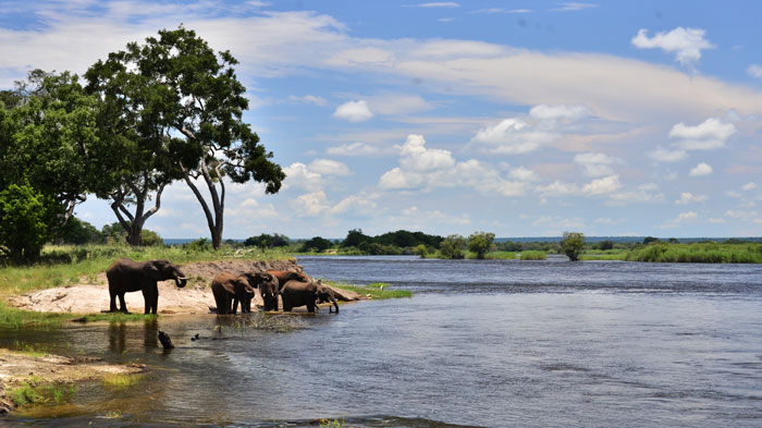
Victoria Falls and the Zambezi River at Zimbabwe’s Zambezi National Park
The Zimbabwean Zambezi National Park and the river that runs through it.
The Mwinilunga District, near to the intersection of the borders of Zambia, Angola, and the Congo, is where the mighty Zambezi River begins its journey downstream. This area is roughly 1,500 meters (4,900 feet) above sea level.
From there, it travels through Zambia, Angola, Namibia, and Botswana before looping back along the frontier between Zambia and Zimbabwe and emptying into the Indian Ocean at the delta in Mozambique. A catchment area of 1,390,000 square kilometers, or almost half the size of the Nile’s, feeds the river.
Distance from its beginning to its end in the Zambezi delta
How far the Zambezi flows
Kariba Dam in Zimbabwe and Cahora Bassa Dam in Mozambique are two of the dams along the Zambezi River that have been built to harness the river’s power. The hydroelectric electricity generated by these dams is crucial to the economies of Zambia, Zimbabwe, and South Africa.
Recent press articles have raised concerns that the Zambezi Seaway Project, a plan to widen the river so that products and minerals may be shipped from the interior, will once again move forward. Learn more and share your thoughts by clicking here.
Another major cause for concern is the revival of long-dormant plans to construct a hydroelectric dam in the Batoka gorge just beneath Victoria Falls. We’re still keeping an eye on and fighting this dangerous project, and you can read more about it by clicking on “Batoka Gorge Dam Project.”
Beautiful scenery and excellent opportunity to observe wildlife draw visitors from all over the world to the river. Along the banks of the Zambezi River, you may come across hippopotamuses, crocodiles, elephants, and lions, among other species.

To better appreciate this incredible river, I propose we divide it into three parts:
zambezi upper
Starting in Zambia, the 240-kilometer-long river then flows south-west into Angola (150miles). During the wet season, the river is around 400 meters (1,300 feet) wide and rushes swiftly over the Cholwezi rapids and the Chavuma Falls before entering Zambia again.
About 800 kilometers (500 miles) to the south, the river has a relatively modest plunge of 180 meters (590ft). Once the river enters the Barotse Floodplain, an area where its breadth can increase to 25 kilometers (16 miles) during the rainy season, its current becomes extremely slow.
Pastoralists, farmers, and fishermen make up the small population in the Zambezi River’s higher reaches. During the rainy season, when the plain is inundated, the locals hold a ceremony called the Ku-omboka Ceremony before fleeing to higher land.
According to local legend, the Zambezi River is inhabited by a spirit named Nyami Nyami, who provides the locals with water for agriculture and food in the form of fish.
Turning east at the Katima Mulilo rapids, it divides Zambia from Namibia.
Trip on the upper Zambezi River, close to Victoria Falls, Zimbabwe
Victoria Falls and the Zambezi River upstream
A short section of the border between Botswana and Zimbabwe follows, after which it becomes the boundary between Zambia and Zimbabwe along the Chobe River. These four countries—Botswana, Namibia, Zambia, and Zimbabwe—join together at this point. From there, it’s another 80 kilometers or so down to Victoria Falls.
Tour companies in Zimbabwe and Zambia provide kayaking, canoeing, river cruises, and daily floats in this section of the Zambezi River upstream of the falls. Spectacular islands and canals, gin-clear waters, and sandy beaches make this stretch of river unforgettable. Birds and other creatures abound there.
Approximately 20 kilometers of the river’s shoreline are located within the Mosi-oa-Tunya National Park in Zambia, while on the Zimbabwean side you’ll find the Zambezi National Park and a number of modest lodges that merge into the banks of the river.
Middle Zambezi
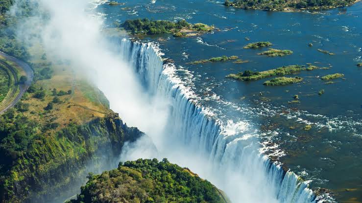
Victoria Falls mark the transition between the upper and middle Zambezi. The river then forms the border between Zambia and Zimbabwe for the subsequent 500 kilometers. After plunging over the Falls, the river proceeds eastward for another 120 miles (200 kilometers), carving deep gorges through basalt rock that are between 200 and 250 meters (660 and 820 feet) in height. These canyons are now home to organized white water rafting tours. When it comes to river quality, the Zambezi is ranked as a level five river. This is the highest grade that a river can be graded for white water rafting, indicating this is as wet and wild as it gets. Several extreme sports take place at the Victoria Falls, with the world-famous bungee jump from the Victoria Falls Bridge being one of the most well-known.
There is a chasm in Victoria Falls called the Gorge.
The Zambezi River as it plunges into the valley below the Falls.
Before reaching Lake Kariba, the river descends another 250 meters over the course of 200 kilometers. One of the largest artificial lakes in the world is contained within the Kariba Dam, which was finished in 1959. To a large extent, Zambia and Zimbabwe now have access to reliable, affordable electricity thanks to the dam’s hydroelectric power.
With a total length of 226 kilometers and a maximum width of 40 kilometers in some spots, Lake Kariba is home to a robust commercial fishing industry and a popular tourist destination.
One of the best places to take a vacation on Earth, because to its breathtaking landscapes, beautiful sunsets, and abundance of fishing and boating activities. Even in the middle of winter, the days are warm and the nights are lovely, with plenty of sunshine and a low chance of precipitation.
The river turns east from the Kariba dam wall and flows back towards Chirundu. As the river continues through Chirundu, it is bounded on either side by two national parks: Zambia’s Lower Zambezi National Park and Zimbabwe’s Mana Pools National Park. The world-famous canoe safaris operate along this section of the river.
When the sun sets over Kariba
Travelers can either paddle down the river and camp out on the banks for the night, or they can stay in one of the safari lodges that dot the riverbanks. Amazing wildlife encounters, including those with Hippopotamuses, are had as the boats glide gently past.
One of Africa’s most significant unspoiled landscapes can be found in the middle section of the Zambezi. As the river reaches the man-made Cahora Bassa Lake, it no longer counts as part of the middle Zambezi.
Historically, this area was home to a section of the Zambezi River known as Kebrabassa Rapids, which made it impossible for early explorers to bring huge ships up the river.
Rivers of the Lower Zambezi
Large ships may make their way down the river from Cahora Bassa all the way to the Indian Ocean. At this 650 km (400 mi) stretch, the river enters a big valley and expands out across a large area, making it shallow in many places, especially during the dry season. The river does not become a gorge until it flows between steep hills at the Lupata Gorge, 320 kilometers (200 miles) from the mouth.
Elsewhere, the water is calm, and there are numerous side channels to investigate. During the wetter months, the river’s sandy bottom and low, reed-lined banks merge into a single, swiftly moving body of water.
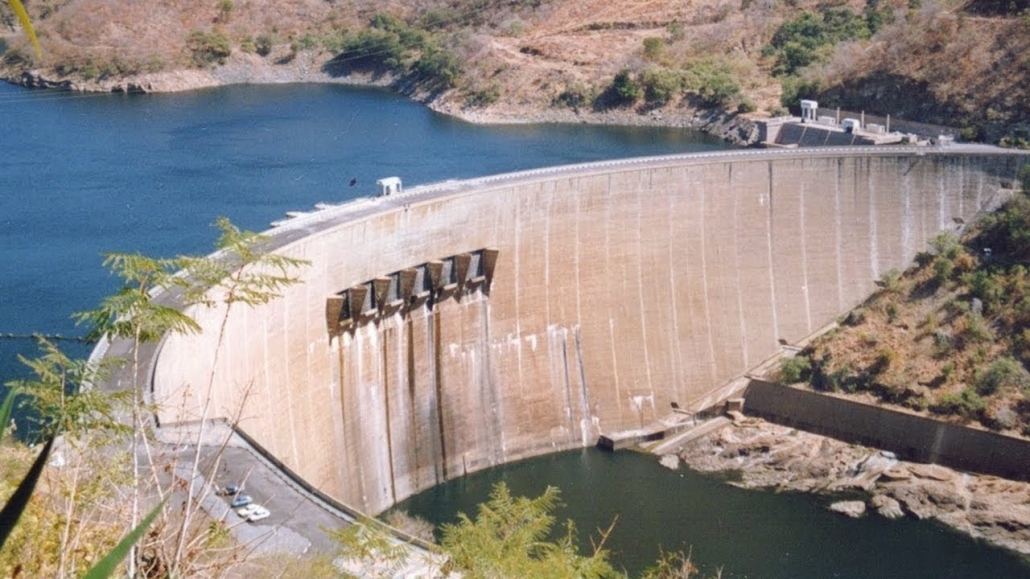
Lower Zambezi River at the Mozambican Cahora Bassa Dam
An Image of Mozambique’s Cahora Bassa Dam
The Delta of the Zambezi
The Shire River brings water to the Zambezi from Lake Malawi, approximately 160 kilometers (100 miles) from the mouth. As the river reaches the Indian Ocean, it divides into several channels, giving rise to the Zambezi Delta.
The Indian Ocean can be reached from the Zambezi Delta in Mozambique.
Indian Ocean and the Zambezi Delta
The mouths of the Milambe, Kongone, Luabo, and Timbwe rivers are all blocked by sand. A northern fork, called Chinde, is used for navigation; its minimum depth is 2 meters at the mouth and 4 meters inside. The delta is now about half as wide as it was before the Kariba and Cahora Bassa dams were constructed, which is a direct result of their construction.
very nice article
https://www.cheaprwandasafaris.com/